Road Developments, 24th May 2020 145/66 likes/comments
A number of people requested the history of their roads: Sue Wilson, Barrow Road; Beccy Apple, St Johns Street; Maralyn Bradnick, Randall Road; Evets Taylor, Clarendon Road. This article includes the part all four of these roads played in the expansion of the town.
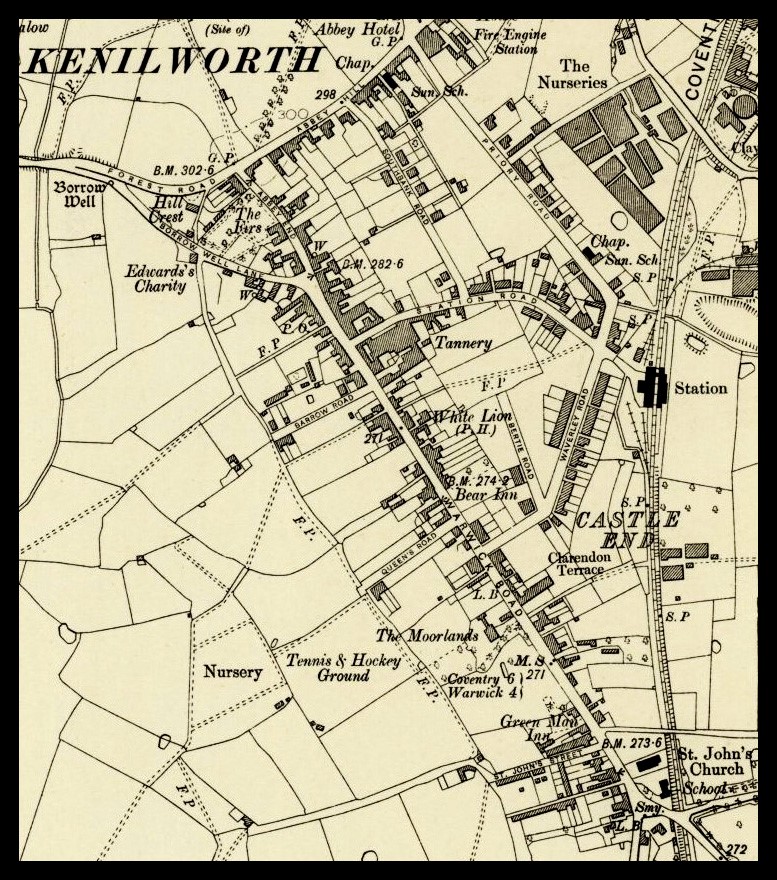
Just 120 odd years ago, Kenilworth’s population was pretty much contained within an inverted triangle with Warwick Road–Clinton Lane to the west, High Street–New Street to the north, and the railway line to the east. Even within that triangle, Priory Road, Waverley Road, Bertie Road and Henry Street had been built within the previous 15 years.
The only protrusion westwards was the cul-de-sac St Johns Street off which to the south were Whites Row and Rawlins Row. From the end of St Johns Street and heading northwards parallel to Warwick Road was a footpath, today’s jitties, which ran along the western boundary of the ‘new’ borough of Castle End when it was formed in the 12thcentury; trackways led from this to both Warwick Road and out into farmland.
The ‘breakout’ westwards from Warwick Road began in 1900. The first road was almost opposite the tannery gates on land owned by the tannery; on it had been a huge reservoir that served the tannery but had become redundant. The road was named Barrow Street, later Road, after the tannery and land owner Samuel Barrow snr, and was adopted in November 1900. The first resident, tannery manager Obidiah Woods, lived at today’s number 31, then named Glencoe; this house marked the road’s extremity, it only went as far as the jitty.
That same year, Leamington’s Mr Bowen built a road along the trackway that led to the town’s cricket ground, later tennis club; at a time of great patriotism during the Boer War, it was named Queen’s Road; again it only went as far as the boundary of the jitties due to the land beyond being in different ownership.
On the other side of Warwick Road, the railway line provided a significant obstacle to opening up the land further to the east. The first attempt was made in 1905 by Joseph Mayfield, a paper mill owner, who proposed ‘making up’ the trackway from Warwick Road that ran in front of Clarendon Terrace into a proper road, and then extending it across the railway line to open up the building land on the other side; this land was owned by Henry Hawkes who also owned the Whitemoor brickyard; the scheme was a joint venture. These proposals had a new road running north-south (much as Farmer Ward Road does today) with a couple of other roads branching from it across to Windy Arbour. At that time, the trackway from Clarendon Terrace crossed the railway at a level crossing, suitable for pedestrians and horse-drawn farm vehicles, but for the new scheme to pass the planning stage, this had to be replaced by a bridge to carry the road over the railway. Due to this the scheme failed, except for the trackway being ‘made up’ and becoming Clarendon Road. It would be another 50 years until a similar road development scheme went ahead, but still without the railway bridge.
It is a surprising fact that, other than that at St Johns for the gyratory system, no new road bridge has been built to cross over the railway line since it opened in 1844.
The next road development was back at St Johns. In 1913, a cemetery was created in two fields known as The Roselands and so a road needed to be built to reach it. The scheme chosen from several suggestions was to extend St Johns Street along an existing farmtrack and then a sharp turn right to take it to the cemetery, which was approached along a chestnut tree-lined avenue. Very unimaginatively, the road extension was called Cemetery Lane (or Road, both were used). At much the same time, after a campaign led headmaster Andrew Hacking, Kenilworth’s first council housing was built in St John’s Street, today’s 18-40 even, and in the new St Johns Avenue. Hacking is one of those lost ‘stars’ of Kenilworth; as well as being a headmaster for more than 30 years, he instigated Kenilworth’s council housing, and post-World War 2 was involved in starting the still-existing Old Folks Club and the youth club. And, to boot, he also won an award for saving the life of a drowning swimmer off the south coast.
There was no more extension of the road system until 7 or 8 years after the Great War. The first was Moorlands Avenue, built in the grounds of a large mansion of that name, in 1926; again, only as far as the jitty boundary, although a plan existed to extend it further.
Next, new council housing was provided alongside the Cemetery Road in 1926 to 1929. To give a more agreeable address, the first part of the road was named after the fields on which the cemetery was built, Roselands Road; the tree-lined approach to the cemetery became Chestnut Avenue.
In 1927 a thin strip of land that prevented any extension of Barrow Road was sold at a tannery sale of assets after one of its several closures, allowing the road to be extended. Then, in 1928 another road with tannery connections was built westwards, Randall Road named after tannery owner and Councillor Charles Randall.
In 1934, a key road was built by A J Cooke; it was St Nicholas Avenue, originally built as a cul-de-sac from Roselands Road and about the same length as Chestnut Avenue. But, the deposited plans showed St Nicholas Avenue was to be continued to meet an extension of the new Randall Road, and simultaneously giving Queen’s Road a new point of termination. As mentioned, Moorlands Avenue was intended to be extended beyond the jitty and with a sharp turn connect into Roselands Road where a housing gap had been specifically left; however, the very necessary war-time construction of the Clarke, Cluley factory prevented this and the gap became an entrance to the factory. After Clarke, Cluley moved off the site, Moorlands Avenue was finally extended, and the new Dryden Close was created from the aforementioned gap, in 1993.
Since the war of course there has been an incredible expansion of the town both west of Warwick Road and east of the railway line; another time maybe…….
Those interested in this subject, and all Kenilworth’s pre-WW2 council housing, will find a detailed account in my book, Kenilworth People & Places Volume 2.
I don’t have an image to go with this article, but the map from 1905 shows how the ancient boundary along which the ‘jitties’ run dictated the original length of Barrow Road, Queens Road and St Johns Street, although the latter was at this time continued with a farm trackway. Clarendon Road too is incomplete.