Cycle route investigation…..Sustrans Scheme, and my proposal
Latest: Warwick District Council are now (early 2022) investigating the possibilities for an Abbey Fields cycle path; details can be found here: Cycle Path Proposals, 2022
WDC PROPOSALS, All Documents February 2023: 2023 Cycling Documents
Detailed plans were released by WDC in May 2025 as part of the ‘A Path for our Future’ package which includes a consultation for the public to submit. This link is to the outline plans, there is a link lower down to ‘View the plans in more detail’: A Path For Our Future
The above are additions and developments since publication of my original articles, below:
Casual cycling in the Abbey Fields has been a continual topic of conversation almost since the park was formed in 1884 (see The Abbey Fields) and a potential cycle route through the park has been discussed seriously for about 2 decades. When asked, as part of wider questions on Kenilworth’s amenities and future, the Kenilworth public were very much in favour of an Abbey Fields cycle route, as seen in the 2013 Kenilworth Town Survey Analysis, question 16.
Subsequently, “Warwickshire County Council (WCC), as highway authority, allocated funding towards a study to investigate the potential for a cycle route through Abbey Fields. Warwick District Council, as the landowner and manager of Abbey Fields, is supportive of this study”.
Carrying out the task was Sustrans, a charity established to provide a nationwide network of cycle routes, who “want to see a UK-wide network of traffic-free paths for everyone, connecting cities, towns and countryside, loved by the communities they serve”.
Sustrans published their findings Abbey Fields Cycle Route Feasibility Study in 2016.
Sustrans remit included:
“The overriding elements required for incorporation into the design can be summarised as follows:
Minimise the potential for conflict between pedestrians and cyclists by providing a dedicated cycle route.
Minimise visual intrusion of the route on the existing park land.
The route should be suitable for wheelchair users.
The route and its construction should not impact on the local archaeology.
Provide a high-quality connection between Bridge Street and Borrowell Lane”
The cycle route is intended to continue that which reaches Townpool Bridge along what was known as School Lane Meadow, which itself can be considered as an extension of The Greenway which ends at the bridge onto The Common in Forge Road.
It is intended to leave the Abbey Fields to the west in Borrowell Lane, between its junction with Forrest Road and the bridge over the brook. This opens up possibilities to continue to Castle Farm and its sports facilities, and other paths leading south and westwards. Or of course, a northward turn towards the castle.
In between it obviously needs to take in the Abbey Fields facilities: the swimming pool, tennis courts, children’s’ play area, Barn Museum, café, the lake, and so a route to, and thus parking at, the central area is a necessity.
As it is to be suitable for wheelchairs, it must avoid all but the gentlest of inclines.
So, let us expand on the key aspects of each part of the route.
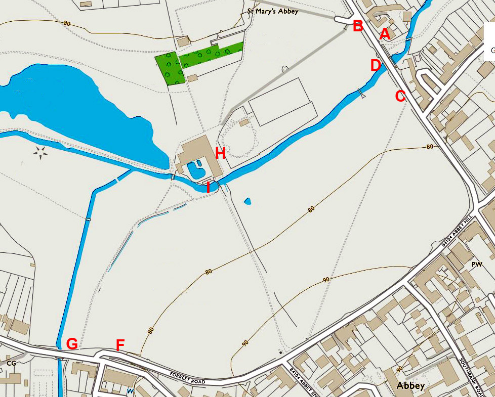 |
Key locations lettered, see text below. |
Eastern entry to the park:
The current cycle path ends when it reaches Townpool Bridge from the east; it terminates at the north end of Townpool Bridge where it meets the road at (A). From that point, logically, the cycle path’s continuance into the Abbey Fields should be at either (B) or (C), the points at which the road and park are on the same level, and due to which there are already paths into the park.
However, if cyclists and pedestrians are to be kept apart as much as possible, there is another alternative; under the bridge where pedestrians are already encouraged to walk from the existing path into the fields (D). However currently for pedestrians this can be problematic as it leads not to a path but straight onto the grass area that is known for becoming waterlogged. For a cycling route there is an additional problem – a lack of clearance under the bridge arch. Even excavating down say two feet would still only leave perhaps a four feet wide central part of the arch with sufficient clearance for an adult on a bike; it would have to be a one-way system, and decent sized excavations for slopes either side.
So, three alternatives; under the bridge or enter at the same point as pedestrians where there is favourable lie of the land.
Western entry to the park:
There are alternatives for a cycle path’s junction with the road; it could come out onto Forrest Road alongside the air raid shelter where there is already a gate used on occasions by vehicles (F), or it could have its junction near or with the footpath (G). Either way, cyclists would then be on the pavement but there is a pedestrian crossing nearby, offering alternatives for the journey’s continuance. Sustrans suggested the possible relocation of this crossing to be more convenient.
Central Area:
The Abbey Fields footpaths, except one, all converge on the central area of the Abbey Fields and the cycle path can be no different as of course it has to provide a route to the facilities that are grouped there. So how can cyclist / pedestrian interaction be avoided, or at least minimised?
A cycle parking space will obviously be needed; Sustrans suggestion is to have it at (H), outside the swimming pool, perhaps the busiest part of the park and likely to become busier when the swimming pool alterations are made (the intention is to increase footfall at pool). It will replace the small formal garden (one of only two such areas in the park).
Another problem is of course the iron bridge (I). The existing bridge is too narrow and its approach from the northern side is a tight double bend, soon to get tighter if the current plans for the new swimming pool are followed; it is a bottleneck, and will become worse. As it is a structure of interest (but I believe not subject to any protection order) it must be kept, it is the oldest structure in the park other than the Abbey. And so, for two reasons, a new bridge will be needed somewhere. Sustrans suggest rebuilding the existing structure as their preferred option, but that will not remove the bottleneck of its approach.
South of the bridge:
In the same way cyclists and pedestrians come together on the north side of the bridge, the south side has a similar problem. Two pedestrian paths converge, and the cycle path would be a third, and so a complicated junction has been designed so that segregation can be achieved, hopefully accident free. The designed junction can be seen in The Problem with Sustrans. Clearly, it would be better to avoid such a complicated interaction.
In summary, there are two or three possible points of entry to the park at each end of the path; the path must serve the central area, there has to be a cycle parking area, and a new bridge is needed. How is the best way to incorporate these into the Sustrans remit (above) without creating as many problems as Sustrans have with their design?
Here is my solution:

Red:
I have retained two options for entering the park at the eastern end.
Although in many ways the route under the bridge is preferred, as it is the direct continuance of the existing path, it does have difficulties. Firstly, its clearance is restricted and large earthworks may be required, but also access to the park by bike is restricted to those already on a cycle path; consideration should be given to those arriving at the park by road cycling; if there were not a connection to the cycle path, road cyclists would use the swimming pool path, defeating the object.
Cycling access to the park can be gained by using the car park entrance; pedestrians have to be wary here due to cars so additional cycles for a few yards to an immediate left turn as shown should not be a problem. In any case, little expense would be incurred by widening the entrance to provide a dedicated cycle path.
Perhaps both options, under the bridge and from the car park entrance, could be included.
There is one other point to be considered on the red part of the route; there is a well-used wooden bridge over the brook that has no surfaced pathways to it on either side. Some form of pedestrian crossing should be considered, maybe as simple as a painted area on the cycle path.
Light Green:
A cycle parking area is needed. I have marked the area alongside the tennis courts and show two access paths, one to the swimming pool, the other between the tennis courts and children’s play area.
Consideration should also be given to having the cycle park between the brook and children’s play area, creating the extra space by moving the children’s play area fence, perhaps no more than 4 or 5 yards. If needs be, the play area could in turn be expanded behind the tennis courts.
If thought necessary, the cycle park could be fenced in such a way that cycles can only enter and leave by the routes, but extra gates for pedestrians can be added.
I prefer my second location option; this keeps the cycles closer to the central area yet still tucked away a little, and away from pedestrians.
Blue:
As mentioned, a new bridge over the brook will be needed. As shown, it can be close to the exit to the cycle park, but can be in one of a number of similar places dependent upon the precise layout of the cycle park. I have drawn the bridge on a skew; that would obviously be more expensive than one that isn’t, that would be for the engineers to decide.
The great advantage of this route is that in the entire park, pedestrian paths and the cycle path come together at just one point, the minimum that can be achieved, a ‘crossroads’ with the War Memorial path. There are ‘standards’ for this sort of junction; a simple zebra crossing with pedestrians having right of way would be the easiest and least intrusive, and one with which all users would be familiar.
The route then follows the southern side of the hedge which separates it from the pedestrian path (which the writer hopes will in any case be upgraded where possible to a more suitable width).
Again, at the western exit both possibilities are marked; the cycle route’s own way onto the pavement, or crossing through the hedge (there is a gap) to give a joint entrance / exit, with / near, the pedestrian path.
Summary:
The great advantages of this route are:
1) Unlike any other proposal, all the criteria of Sustrans remit are met.
2) There is minimal interaction between cyclists and pedestrians; no shared path at any point, and just one crossing point with a pedestrian path.
3) Cyclists will not be in the busy area outside the swimming pool, cyclists will not contribute to the congestion on the northern approach to the Iron Bridge.
4) The existing very old Iron Bridge can be retained in its current form.
5) The route covers no area known, or suspected, of having buried archaeology.
6) The route provides access by bike to all the Abbey Fields amenities, both for those using other cycle paths, and those cycling by road to the park.
7) With the likely exception of the access under the Townpool Bridge at Bridge Street, there will be no notable gradients.
What needs to be further investigated:
1) The best means of access at each end of the cycle path, to ensure cyclists are not tempted into using pedestrian paths.
2) The best means of a ‘crossing’ on the south side if the Iron Bridge.
3) If any form of a crossing would be needed on the north side of the wooden bridge.
4) The precise size and location of the cycle park.
5) The precise location and design of the new bridge, in conjunction with 4).
These are path dimensions as recommended by The Department of Transport:
Pedestrian & Cycle Path dimensions
In these articles I take a look at other proposed schemes and the involvement of some ‘Stakeholders’:
The Problems with the south bank…..
The Problems with Warwick District Council…..
The Problem with Kenilworth Town Council…..
The Problem with Friends of the Abbey Fields…..
The Problem with English Heritage……
More Abbey fields articles:
How the land was acquired Full details on how each plot became part of the park between 1884 and 1974.
The Covenants Each plot came with a covenant and restrictions
The Swimming Pool The history of the pool from its origins in the 1890s until the present day, with a number of photographs
Car Parking in the Abbey Fields How the car park came about
Bye-laws The non-observance of bye-laws is often discussed, here you can see them all
Abbey Fields Archaeology A guide to the many archaeological explorations of the Abbey and its surroundings from 1840 to the present day
Abbey Fields Play Equipment Some aspects of the park play equipment, now established over a century
Abbey Fields, 1947 A look at the park as it appeared in the national aerial record of 1947
Abbey Fields Timeline A chronology of the Abbey Fields starting in the ice age!
Return to Abbey Fields home page
See also my book: