The problem with Sustrans…….
In February 2016, Sustrans published their Abbey Fields Cycle Path Feasibility Study. It favoured ‘Option C’ in yellow……
![]()
…which created this ‘junction’ around the Iron Bridge (Abbey Fields Cycle Route Study Report Summary, 9th August 2016)…..
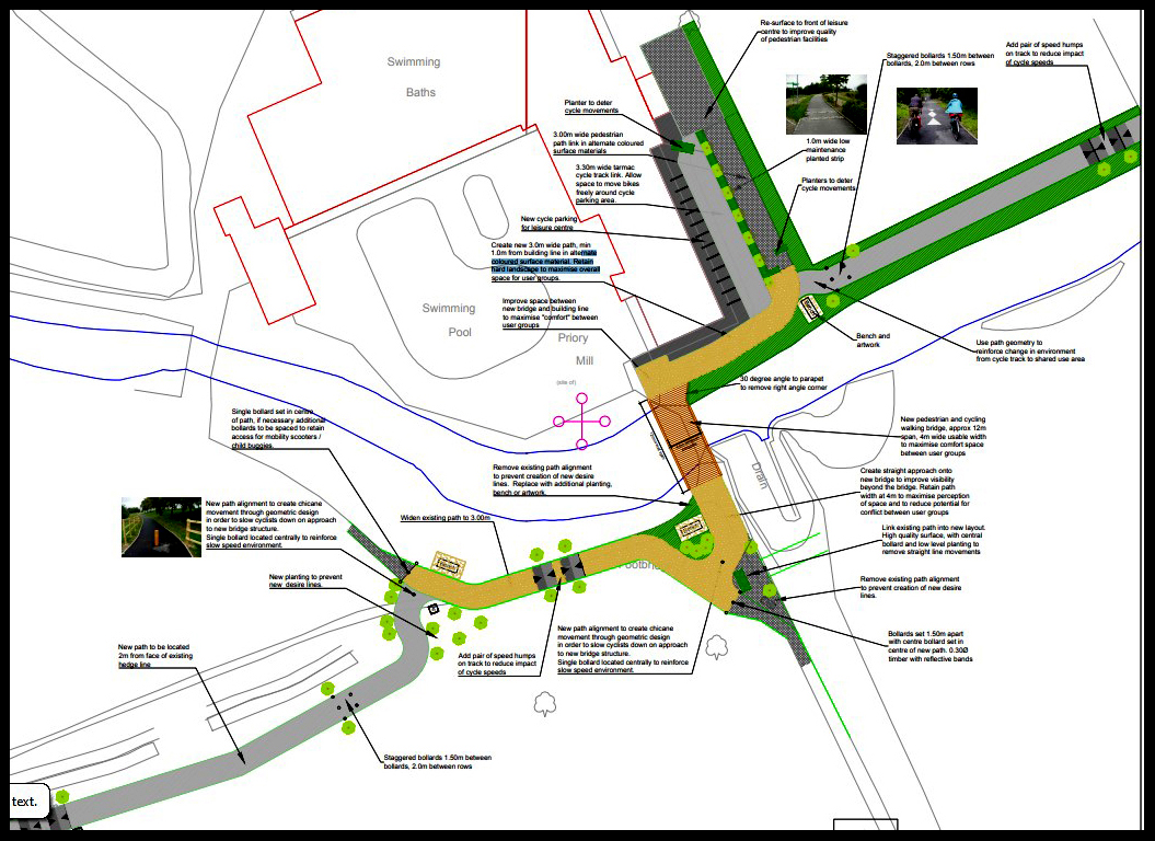
It includes a new bridge replacing the existing one, and pedestrians and cyclists sharing paths in the busiest part of the park.
Sustrans ‘Study Approach’ (Abbey Fields Cycle Route Study Report Summary, 9th August 2016) includes the statements that:
‘The key criteria for the cycle route were to…..
Minimise potential for conflict between pedestrians and cyclists, particularly around the children’s play area and near the swimming pool.
Avoid impact on local archaeology and historic features in the park.’
It would seem these two key criteria were overlooked when a) deciding the iron bridge, the oldest structure in the park other than the Abbey, had to be demolished and b) ensuring pedestrians and cyclists unavoidably met in the busiest area of the park next to the swimming pool, and both would have to negotiate a series of new convoluted bends and junctions.
Clearly a shared path in that busy area should be avoided.
How Sustrans chose this route is seriously open to question, particularly with its dismissal of ‘Option A’ (orange in the plan), that on the south bank of the brook. Roughly opposite the children’s play area is a large depression, about which, it states:
‘The clear depression in the landform is the site of the Priory Mill and as such is of important historical value.’
It is accepted that the site of the Mill would in fact have been on the site occupied by the swimming pool, Priory Mill site, Abbey Fields. Topography supports this; it was on the Abbey Pool retaining bank, and there is a double bend in the brook, both features common with mills as seen in other locations even in Kenilworth (at the tiltyard, School Lane Meadow and Forge Road).
How this error was made is clear in the map above, part of Sustrans submission; the map shows the words ‘Priory Mill’ at the location of the depression; however, the symbol marking the site of the antiquity is on the swimming pool site.
In these articles I take a look at other proposed schemes and the involvement of some ‘Stakeholders’:
The Problems with the south bank…..
The Problems with Warwick District Council…..
The Problem with Kenilworth Town Council…..
The Problem with Friends of the Abbey Fields…..
The Problem with English Heritage……
Return to Abbey Fields Cycle Path Home Page